

By the President of the United States of America
A Proclamation
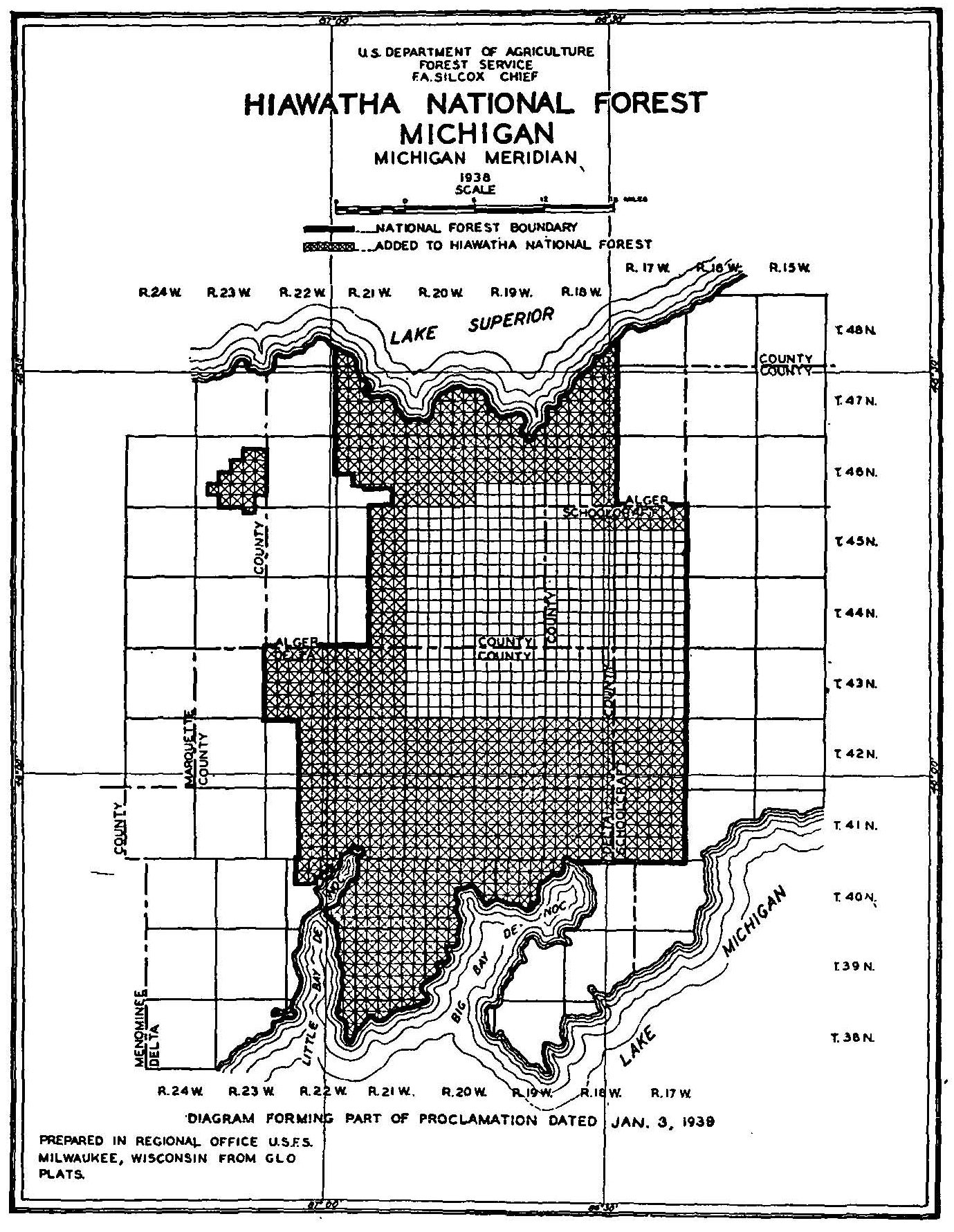
Whereas certain lands adjacent to the Hiawatha National Forest within the State of Michigan have been acquired or are in process of acquisition by the United States under authority of the act of March 1, 1911, c. 186, 36 Stat. 962 (U.S.C., title 16, sec. 516), as amended by the ait of June 7, 1924, 43 Stat. 653 (U.S.C., title 16, sec. 515), the act of March 31, 1933, c. 348, 48 Stat. 22 (U.S.C., title 16, sec. 585), section 5 of the act of March 3, 1925, 43 Stat. 1132, 1133 (U.S.C., title 16, sec. 555), the National Industrial Recovery, approved June 16, 1933 (48 Stat. 202, U.S.C., title 40, sec. 403), and the Emergency Relief Appropriation Act of 1935, approved April 8, 1935 (49 Stat. 115); and
Whereas it appears that the said lands and certain intermingled public lands are suitable for national-forest purposes, and that it would be in the public interest to reserve them as part of the said Hiawatha National Forest:
Now, Therefore, I, Franklin D. Roosevelt, President of the United States of America, under and by virtue of the power vested in me by section 24 of the act of March 3, 1891, 26 Stat. 1095, 1103 (U.S.C., title 16, sec. 471), the act of June 4, 1897, 30 Stat. 34, 36 (U.S.C., title 16, sec. 473), and the acts above mentioned, do proclaim (1) that all lands of the United States within the following-described boundaries, as shown on the diagram attached hereto and made a part hereof, are hereby included in and reserved as part of the Hiawatha National Forest in the State of Michigan; and (2) that all lands within such boundaries which are now in process of acquisition by the United States under authority of any of the above-mentioned acts shall upon the acquisition of title thereto become and be administered as part of the said Forest:
MICHIGAN PRINCIPAL MERIDIAN
T. 38 N., R. 21 W., all that part lying north and west of Big Bay De Noc, Lake Michigan.
T. 38 N., R. 22 W., all that, part lying east of Little Bay De Noc, Lake Michigan.
T. 39 N., R. 20 W., all that part lying north and west of Big Bay De Noc, Lake Michigan.
T. 39 N., R 21 W., all.
T. 39 N., R. 22 W., all that part lying east of Little Bay De Noc, Lake Michigan.
T. 40 N., R. 19 W., all that part lying north of Big Bay De Noc, Lake Michigan.
T. 40 N., R. 20 W., all that part lying north and west of Big Bay De Noc, Lake Michigan.
T. 40 N., R. 21 W., all.
T. 40 N., R. 22 W., all that part lying east of Little Bay De Noc, Lake Michigan, and sec. 2; N½ and SW¼ sec. 3; secs. 4, 5, 8; N½ and SW¼ sec. 9.
Tps. 41 N., Rs. 17, 18, 19, 20 and 21 W., all.
T. 41 N., R. 22 W., secs. 1 to 3, inclusive; secs. 10 to 15, inclusive; secs. 22 to 27, inclusive; secs. 34 to 36, inclusive.
Tps. 42 N., Rs. 17, 18, 19, 20 and 21 W., all.
T. 42 N., R. 22 W., secs. 1 to 3, inclusive, secs. 10 to 15, inclusive; secs. 22 to 27, inclusive; secs. 34 to 36, inclusive.
Tps. 43 N., Rs. 21 and 22 W., all.
T. 44 N., R. 21 W., secs. 1 to 3, inclusive; secs. 10 to 15, inclusive; secs. 22 to 27, inclusive; secs. 34 to 36, inclusive.
T. 45 N., R. 17 W., secs. 1 to 12, inclusive.
T. 45 N., R. 18 W., secs. 1, 2, 11 and 12.
T. 45 N., R. 21 W., secs. 1 to 3, inclusive; secs. 10 to 15, inclusive; secs. 22 to 27, inclusive; secs. 34 to 36, inclusive.
T. 45 N., R. 23 W., N½ sec. 2.
T. 46 N., R. 18 W., secs. 1 to 26, inclusive; secs. 35 and 36.
T. 46 N., R. 19 W., secs. 1 to 24, inclusive.
T. 46 N., R. 20 W., all.
T. 46 N., R. 21 W., secs. 1 to 18, inclusive; E½ sec. 20; secs. 21 to 25, inclusive; sec. 26; N½N½ sec. 27; N½NE¼ sec. 28; sec. 36.
T. 46 N., R. 23 W., secs. 11 to 15, inclusive; secs. 21 to 29, inclusive; secs. 33, 34, and 35.
T. 47 N., R. 18 W., all that part lying south and east of Lake Superior.
T. 47 N., R. 19 W., all that part lying south of Lake Superior.
T. 47 N., R. 20 W., all that part lying south of Lake Superior.
T. 47 N., R. 21 W., all that part lying south and west of Lake Superior.
T. 48 N., R. 18 W., all that part lying south and east of Lake Superior.
T. 48 N., R. 21 W., all that part lying south and west of Lake Superior.
The Executive Order of June 4, 1856, withdrawing public land for lighthouse purposes, is hereby revoked. Executive Order No. 4430 of April 23,1926, and Executive Order No. 6964 of February 5, 1935, as amended, withdrawing public lands for classification, are hereby revoked in so far as they affect any of the above-described lands.
In Witness Whereof I have hereunto set my hand and caused the seal of the United States to be affixed.
Done at the City of Washington, this third day of January in the year of our Lord nineteen hundred and thirty-nine, and of the Independence of the United States of America the one hundred and sixty-third.

FRANKLIN D ROOSEVELT
By the President:
SUMNER WELLES
Acting Secretary of State.
Related Images
Franklin D. Roosevelt, Proclamation 2318—Enlarging the Hiawatha National Forest—Michigan Online by Gerhard Peters and John T. Woolley, The American Presidency Project https://www.presidency.ucsb.edu/node/357683